Like 2020, this past year will not be remembered by many people primarily for its weather, although it was an extreme weather year in many places.
The most unusual weather event of 2021, by far, in the Pacific Northwest was the late-June “heat dome” which effectively moved the climate of Phoenix a thousand miles north for a few days. Sinking air aloft led to compressional heating, generating temperatures of 90 degrees up at 5,000 feet. Even the summer sun was insufficient to mix these temperatures down to ground level without the help of atmospheric winds. For this reason, Corvallis avoided the most extreme heat, topping out at 107.5 instead of the 117 reached at Salem or the incredible 121ºF reached at Lytton, BC, a day before the town caught fire in the raging winds that finally ushered in cooler air. Many all-time high temperature records were broken by ten degrees, and native trees not adapted to this level of heat were scorched and may struggle to recover.
Although this was another extreme fire season in California and BC, we were lucky in this area both to get some late-season rain in June that dampened fuels and to avoid the summer winds and lightning storms that characterized 2020. Although we could smell smoke in the air on a few days, air quality mostly remained in healthy ranges.
Temperature trends
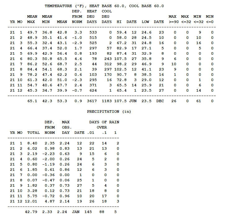
In keeping with recent trends, 2021 featured a warm January, a cold start to spring, and a hot summer. The summer featured 26 days above 90 degrees – a record for my 13 years of record keeping, and a second exceptional heat wave in August that topped out at 102.5ºF, which made few headlines after June. Despite weather models suggesting single digits possible in late December, cloud cover held the lowest temperature to 23.5ºF which was our lowest of the year. Like other recent years, it was not one to challenge the winter hardiness of crops.
Precipitation trends
Despite precipitation totals only marginally below normal, the combination of a dry spring, a hydrologic deficit carried over from previous years, and a hot summer led to this part of Oregon being classified as severe drought by late summer. For all of the news of drought, the rivers kept flowing here, and it was largely a good season for farmers who escaped direct heat damage. As of December the drought classification persists, but I have to assume it will be amended soon, as twelve inches of precip (including 10″ of snow) in December left us with an above-average total for the year for the first time since 2017. As I write this, we are in another flood watch with 4-5″ of rain possible in the days ahead. So I am hopeful that 2022 will not be a drought year.
Monthly notes
January was largely warm and wet, and it featured at atmospheric river on the 12th that dropped 2.24″ of rain – the wettest day of 2021 – and briefly raised the Marys River to its second highest flood on gauge records. Rain fell on 22 out of 31 days, with a total of 8.4″ for the month, and a brief cold snap brought a low of 24.6ºF on the 23rd before warm rain returned.
We just barely missed out on high-impact weather in February, when a stable arctic boundary set up directly over our area for several days from the 11th through the 13th. The Seattle area saw cold snow, and the northern Willamette Valley from Portland to just five miles north of Corvallis saw ice accumulations up to 1.5 inches that decimated trees, left forests looking like a hurricane had passed through, and left some areas without power for two weeks. Here, we had hours of rain at 31.6 degrees, which left a light glaze on twigs but melted as fast as it froze, causing no damage or power outages. Aside from that storm, February was cool and wet but mostly seasonal.
March had the year’s largest cold anomaly, at 2.9 degrees below normal, despite only 50% of normal precipitation. It didn’t feel especially cold, as many days had freezing nights and 55-65 degree highs with sunshine. The spring drought would continue.
April was exceptionally dry, with rain on only five days totaling 0.60″ or 23% of normal. Our last frost came on the 12th, and we reached 80 degrees on April 17th.
May continued the spring drought, with 0.80″ of rain or 40% of average. Temperatures were seasonable, with some 80-degree days but also plenty of 60-degree days. We came close to having a late-season frost on the 8th (32.9ºF), but early-planted tomatoes and peppers survived.
June – usually a rather nondescript month weatherwise – was full of extremes this year. The month started with a high of 95.7, which was followed by a cold spell with a low of 35.8 on the 9th. Coming out of the cool weather we had an unusually strong late-season low pressure system which dropped 1.5″ of rain on the 12th and 13th, contributing to a monthly total of 1.85″ (50% above normal) which delayed fire season but unfortunately was too little too late to offset the spring shortfall. The rain gave way to a week of July weather (highs 80-90), which was followed by the heat dome event, with 102.7 on the 26th and 107.5 on the 27th. The sea breeze front that shoved out the hot air on the 28th brought some of the year’s strongest winds, breaking branches off of oak trees and knocking out power to my shop. June averaged 4.6 degrees above normal – the largest temperature anomaly of 2021.
After the wildness of June, July was a mellow month, if still hot. We had ten days at 90 or above, but none above 100, averaging 2.5 degrees above normal with almost 100% sunshine and zero rainfall.
The first half of August continued the summer of heat, topping out at 101.4 on the 11th and 102.5 on the 12th. This is the first time I have recorded four days above 100 in one year; parts of eastern Oregon and Washington had many more as the hot pattern remained in place from late June through mid August. Mid-month brought a surprising and most welcome break from the heat, with most days for the rest of the month in the 70s and low 80s, and a few drops of rain (0.07″ total) on the 25th and 26th.
September was a month of beautiful weather, with substantial rain on the 17th-19th and again on the 27th bringing the monthly (1.82″) total a bit above normal and allaying fears of a repeat of the September 2020 firestorms.
October brought a resounding first frost (29.0ºF) on the 12th, which would prove to be the only freeze of the month. That made the growing season of 2021 exactly half of the year, from April 12th to October 12th. The second half of the month shifted into a cool, wet, November-like pattern, making it feel like we mostly missed out on autumn this year. Total rainfall, at 3.28″, was again just a bit above normal.
The first half of November continued the rainy pattern, with rain on each of the first 12 days. The latter half of the month brought a mix of brief cold snaps, intermittent rain, and 60-degree days after Thanksgiving. It can be tough to reach normal rainfall in usually-soggy November, and the total of 5.75″ was a bit shy.
December began with a clear 65-degree day – the only such day that I can remember in any Oregon December. That would be followed by precipitation on 26 of the following 30 days, ultimately totaling 12.01″ or 68% above normal even for the typically-wettest month of the year and bringing the annual total to 42.79″, hopefully putting an end to our long-standing drought. The 11th and 19th brought atmospheric rivers, with the 19th-20th bringing another flood to the Marys River. Arctic air arrived on Christmas night, with around 10″ of snow falling over the next two days – ending a long drought without significant snowfall dating back to February 2014. The cold air stuck around with the snow melting gradually over the next few days, but nighttime clouds prevented radiational cooling, keeping lows in the 20s instead of the teens and single digits predicted by weather models.
As I write this, southerly winds have put an end to the cold snap, with a wind advisory posted for tonight and a flood watch out for another atmospheric river tomorrow. I am grateful that we are headed into 2022 with a rainfall surplus and a healthy snowpack in the mountains. We shall see what the next year brings.
2 Responses to 2021 Weather Summary