Another year around the sun. Another year of global extremes in our changing climate, though a bit of a respite here in Oregon – at least from the summer heat.
This past year will be remembered by most as a return to the way summers used to be in the Pacific Northwest. Hemp farmers and those living in the Willamette River floodplain will remember it as a year of struggle and loss, but for most it was a year of sufficient rainfall, few wildfires, ample harvests, and mild summer days.
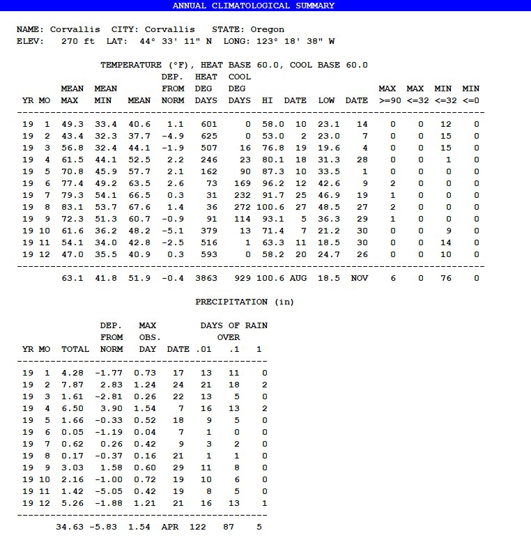
Temperatures averaged slightly below long-term normals for the first time since 2013. A warm spell from April through June – a good start to the growing season – was offset by an anomalously cold February-March and some record or near-record cold nights in October and November. We had 76 days with below-freezing nights – the most since 2009 – and only six days above 90 degrees, down from the 17-20 hot days of the previous four summers.
Precipitation finished 15% below average, which leaves us on the edge of a drought. Though finishing not far from normal, rainfall in 2019 was extremely erratic. February and September brought many days of rain and April had a 10- or 20-year flood (with the heaviest totals to our south). In between, March and June were rather dry, and since October 1 we have only had 50% of normal rainfall, which as of this writing has returned the region to drought status. Hopefully we can catch up in the remaining winter months ahead.
January was warm, reaching 58 degrees on the 10th. Dry spells from the 10th to the 16 and the 24th onward brought warm winter sunshine with frosty nights in the 20s.
A weather switch flipped on Feb. 3, plunging much of the nation into a monthlong cold snap that brought snowstorm after snowstorm to the Midwest and contributed to record spring flooding. Here on the western fringe, we had no temperatures above 50 from Feb. 3-28, and lots of very cold rain a few degrees away from heavy snow. We did see snow on at least three occasions, but never more than a quick-melting inch. The last February storm on the 25th-26th dumped over a foot of heavy snow on Eugene, Roseburg, and surrounding areas, bringing down thousands of trees and knocking out power to some places for weeks.
March was mostly continued cool, but with a warm nine-day dry spell in the middle topping out at 76.8 degrees on the 19th. This after a low of 19.6 on the 4th and a brief morning snowfall on the 8th. Precipitation was only 36% of average, sandwiched between the soggy months of February and April. Early spring can be a steady stream of cool showery days or a rollercoaster of temperatures and storms. This year was definitely more of a rollercoaster.
April started with 15 days of rain, punctuated by an atmospheric river on the 6th and 7th that led to the first-ever-recorded April flood on the Willamette River. As in the February snowstorm, the heaviest totals ended up over Eugene with no local flooding on the Marys or other rivers, but the rain coupled with rapid snowmelt pushed the Willamette higher and higher, cresting at its highest level since 1996 and closing Highway 34 east of Corvallis for several days. For those living and farming in the floodplain, it was a week of stress followed by a month of mending fences, but inundated crops largely survived, thanks in part to the warm spring weather that followed. From the 21st onward we had no precipitation, just beautiful spring days and fields slowly drying enough for planting.
May started with 13 sunny days and temperatures climbing each day to 87.3 on the 10th. Early-planted beans and tomatoes thrived. Untilled soil crusted and cracked, and it seemed we forgot the flood a mere month prior and were soon wishing for rain. Rain did arrive on the 14th and continued on and off for the rest of the month, watering in dry-farmed crops and bringing the monthly total close to normal.
It seemed in June that we might be in for yet another hot, dry summer, as the rains largely ceased and we topped 95 degrees on the 12th. But late-month rains (that unfortunately coincided with my weather station being offline, so don’t show up in the totals) marked a pattern shift that continued through the rest of the summer.
July is often a month when Oregonians forget about the weather and simply enjoy it. Such was the case this year, with mostly pleasant days in the 70s and low 80s. Rain on the 9th-10th and 15th caused some hand-wringing for hay-cutters, but also helped to extend the nectar flow for bees and delay the fire season.
August brought more of the same, though just a bit warmer. A little rain on the 21st didn’t put much of a damper on seed harvests. We did finally make it to 100 degrees – 100.6 to be exact – on the 27th, but with low dew points and humidities it didn’t seem especially oppressive. In fact, the morning of the 27th started out at 48.5 degrees, for an amazing daily swing of 52.1 degrees while also registering both the warmest and coldest readings of the month on the same day.
Oregon’s burgeoning hemp industry will rue September, which brought rain on the 8th followed by four more rainy spells with only a few dry days in between. On the 28th the temperatures turned to fall, with lows in the 30s and highs around 60, creating ideal conditions for botrytis mold on the CBD-rich flowers. It wasn’t all that unusual for September, all told, but the young industry had come of age in the warm, dry summers of 2015-18 and – after losing up to 50% of the crop – had a wake-up call that this climate is not always the best for a plant that falters in autumn damp. We at Wild Garden Seed were glad that this wasn’t a big quinoa year, and by and large managed by bringing late harvests directly into the greenhouse and seed dryers.
October stands out for its cold nights. Typically we will have one or two light frosts near the end of the month. This year we had our first frost on the 1st, followed by hard freezes in the 20s on the 10th and 11th, and finally record cold all the way down to 21.2 on the 30th – nine subfreezing nights altogether. I protected my peppers through the first one and harvested them all ahead of the second. Crops up on the hill at Wild Garden didn’t freeze until the end of the month, as these were inversion nights and the air aloft was warmer. We had a rainy week mid-month, but by and large October was a time of crisp, clear fall days.
The first half of November – typically our second-wettest month – had no measurable precipitation, much to the consternation of drought-fearing climatologists and much to the delight of fennel-harvesting seed farmers. Instead we had continued sunny days with frosty mornings and highs in the 60s. Rain did arrive on the 15th and continued for the rest of the month, but only added up to 1.42″, or 22% of average for November. On the days after Thanksgiving, a “bomb cyclone” came ashore in southern Oregon, bringing cold winds and temperatures down to 18.5 degrees on the 30th – our coldest reading of the calendar year. Overwintering crops all survived, perhaps sufficiently hardened by the many earlier frosts.
December had no real cold snaps this year, and the rains finally did arrive, though still only 74% of normal. The dry days were mostly foggy or overcast, and production from my solar array set a record low since installation in November of 2017. A solstice atmospheric river stayed just to our north, bringing flooding to Astoria and Olympia but only a quick dose of much-needed rain here. The year ended on a warm note, 52 degrees on New Years Eve.
What will 2020 bring? As I write this it looks like we have a few weeks of cold weather ahead, with plenty of rain and some snow possible at times. Meanwhile Australia is experiencing all-time record heat and drought, with fires that dwarf anything California has seen thus far. With the climate system in flux, extremes are becoming more common. We shall see…