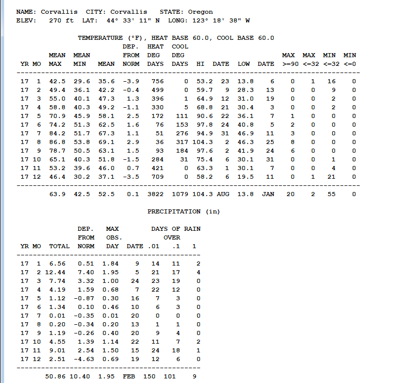
In keeping with my dad’s tradition of publishing an annual weather summary, I thought it would be worthwhile to say a few words about 2017. Here are the data:
In some ways, 2017 was an “average” year – in terms of overall temperature, length of growing season, total number of days with measurable rainfall. However, looking at seasons separately, some anomalous patterns emerge – and these are the same patterns predicted to be the “new normal” for our region by climate change models.
- While the whole year averaged out to normal temperature, May-Sept averaged 1.9 degrees above normal and the cooler months (Jan-April, Oct-Dec) averaged 1.2 degrees below normal. 2017 had a very hot summer, parts of two cold winters, and near-average temperatures for spring and fall.
- Rainfall, at 120% of normal, was a bit above average, driven primarily by an extraordinarily wet February and March. Breaking that down by season, we had 135% of average rainfall during the wet season but only 69% of average from May-September. Not bad for seed farming, but coupled with low humidity and dry thunderstorms in the Cascades we had one of the worst fire seasons in recent memory.
Climate change models generally predict an overall increase in rainfall though with drier summers and a slight increase in temperature with higher summer highs and more winter extremes. Assuming they’re correct, then 2017 may have been a typical year in a new reality. Can we deal with it? This was not a bad year all told, though it is not so much the new average as the new extremes (droughts, floods, heat waves) that will drive changes in ecology and agriculture – and we won’t know what those extremes will be until they arrive.
A few of 2017’s weather patterns deserve special mention:
- From February through April it rained on 74% of days. If we subtract out one seven-day rain-free window from March 30-April 5, that increases to 80%. At Wild Garden we managed to plant out some early brassicas and spinach in that one window, but everything else had to wait until May. Despite the delay, it was a great year for lettuce and many other crops.
- The heat wave from July 30 through August 4 topped out at 104.3 degrees, which is the highest my station has recorded since my records began in 2008 (though it has been in three different locations so the comparison is not perfect). Later in August and September we had many days of forest fire smoke, which actually helped to moderate high temperatures somewhat. We had 20 days above 90 degrees, which is the highest so far in my records.
- We had 11 consecutive days of 100% sunshine – no morning fog, no rain, minimal high clouds – from December 4-14. I can’t say exactly how unusual that is, but the phenomenon that produced it (persistent high pressure, near record-low atmospheric moisture) also created the devastating wildfires in southern California. Quite possibly connected to climate change, though of course there is no way to draw conclusions from one event.


One Response to 2017 weather summary