The inversion (warm and clear skies above, cold and cloudy in the valley) has now persisted for eight days, with one more day predicted tomorrow before rain moves in with enough wind to mix the air. We might see some freezing rain at first with the cold air still trapped at the valley floor. Temperatures have gradually been cooling in Corvallis, with the last three days failing to rise above freezing.
I made it my goal to get above the inversion at least once each day. With the cloud tops around 1400 feet, that didn’t prove too difficult. On Friday I set out on bike for McCulloch Peak (2155 ft.), the closest 2000-ft. mountain to town. The gravel roads have grades of around 16%, forcing me to stop frequently for air despite pedaling in first gear. (Wider mountain bike tires would probably help as well.)

Semi-obstructed southward view from McCulloch Peak.
From there I descended to a saddle at 830 ft before climbing much gentler 8-10% grades to Dimple Hill (1493 ft), a high point on the north edge of town with a broad south-facing meadow. With the cloud tops just below me, I appeared to be on the edge of an inland sea. Perhaps this is what the view would have been like 30 million years ago, when the Willamette Valley was a large marine bay similar to today’s Puget Sound.

Southwest from Dimple Hill. Marys Peak and a companion mountain are on the right of the pass over which Hwy 34 travels to Alsea. Flat Mountain (see below) is among the lower mountains in the center.

Straight south toward Eugene. Coast Range on the right, Cascade foothills on the left.
I followed mountain bike trails down from Dimple Hill, finishing at OSU after 20 miles and over 3000 vertical feet. Definitely a good workout.
On Saturday I opened my GIS program in search of more highpoints, and settled on the closest 2500 ft+ mountain to Corvallis: Flat Mountain in an area I’ve never explored – a heavily logged mosaic of BLM land and private forests to our southwest. The roads proved to be surprisingly passable, with minimal snow until the last quarter mile to the top, which we decided to hike.

Marys Peak from a different angle, looking northwest.

Three Sisters! We could see (just barely) all the way to Mt. Rainier.

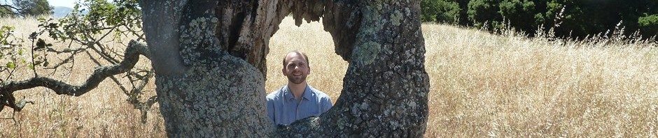
Mark on Flat Mountain. The top is a bulldozed loading area for logs, and the northern slopes were recently clearcut - not great from an ecological perspective but good for views. The island just left of my head is Dimple Hill, and McCulloch Peak is the highest point farther to the left.

Moon! It's been about 10 days since we've seen it down in the valley.

Layers of blue looking toward the coast. The coastal valleys are also cold under the same inversion, but without the clouds and fog.
Last night we slept in our friends’ cabin near Alsea, cozy warm thanks to the woodstove despite a crisp 20-degree night. In the morning we woke to find everything covered in heavy frost – ice crystals up to an inch long.

Frosty morning.

Ice formations on grass blades.